Tropical cyclones, also known as hurricanes and typhoons, are one of the deadliest and most damaging natural hazards.
Fuelled by warm air and seas, tropical cyclones are large storm systems that form in the tropical latitudes.
Nearly a billion people live in places that are impacted by tropical cyclones. Since 2000, tropical cyclones have caused more than US$2.4 trillion in damages globally. Tropical cyclones can be particularly devastating for developing countries that have less economic means to recover and rebuild.
As the climate warms, the most powerful tropical cyclones are expected to become more intense and more likely.
To build resilience and reduce potential damages, communities need to understand how often tropical cyclones are expected to occur.
However, understanding the changing risk of tropical cyclones with climate change is difficult due to a scarcity of data. Globally, only about six very damaging tropical cyclones make landfall every year, and many countries only have less than 40 years of high-quality weather data on tropical cyclones.
The Imperial College Storm Model (IRIS) is an innovative project that helps scientists and the public understand the likelihood of a damaging tropical cyclone.
IRIS is powered by Dreamlab, an app that uses idle, charging smart phones to create a virtual supercomputer. Anyone with a smart phone and an internet connection can download and run the app, to help power IRIS. All of the data is freely available and will be updated frequently as more model user data is received.
How it works
To overcome the scarcity of real-world data, the IRIS model has created a database of millions of synthetic tropical cyclone tracks.
These tracks map the tropical cyclone from formation to landfall and describe how powerful the winds are at each stage of the tropical cyclone’s life.
Crucially, the model can determine the likelihood of a given tropical cyclone wind speed impacting any location in the world. For example, in today’s climate, a Category 5 hurricane making landfall in Florida with winds above 252 km/h can be expected to occur on average only about once every 60 years, while a Category 3 hurricane making landfall in Florida with winds above 178m/h are much more common, expected to occur about once every 30 years, according to IRIS.
This method is described in greater detail in a paper published in Nature.
Results
[Please enable cookies to see the map below]
Map
Figure 1. Map shows the return period of cyclones making landfall simulated during the entire project (October 2022-now). Click the icon for selected regions of interest. The map also shows Category 5 (their lifetime maximum) synthetic cyclones tracks (paths) simulated recently.
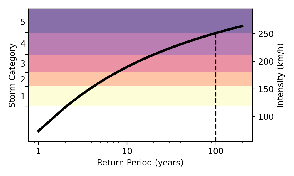
 Figure 2. Illustration of the return period to understand the pop-ups in Figure1. In this example the dashed line shows a 100-year event would correspond to a Category 5 storm.
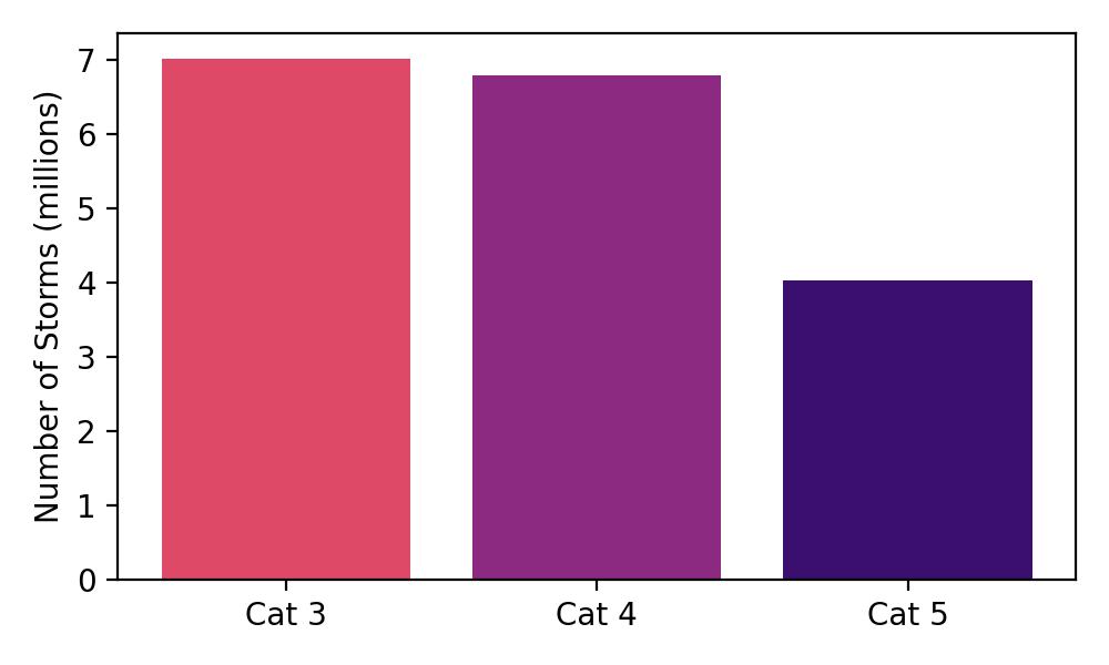
 Figure 3. Number of model landfall damaging cyclones (Category 3, 4, 5) simulated recently by IRIS. We are generating over 100,000 storms every month.
Visualise the data
We now have some first results where all can examine the data. You can find them on the two portals below that are used for risk management, climate change adaptation and disaster risk reduction.
G-SRAT and OS-C (under wind hazard).
Source: Sparks, N., Toumi, R. The Imperial College Storm Model (IRIS) Dataset. Sci Data 11, 424 (2024). https://doi.org/10.1038/s41597-024-03250-y